Wednesday, June 17, 2015

The map that reveals the world is running out of water:The drought that has swept California is now threatening the state’s drinking water supply


The map that reveals the world is running out of water:


Satellite images reveal a third of global groundwater basins are overstressed

  • Arabian Aquifer System, an important water source for more than 60 million people, is the most overstressed in the world
  • Researchers say it's unclear how much water is left in most hard hit aquifers

Satellite data show people are overdrawing water from some of the world's largest groundwater basins.

Researchers from the University of California, Irvine say it's unclear how much water is left in the most overburdened aquifers.

The problem is expected to worsen with climate change and population growth.

Groundwater storage trends for Earth's 37 largest aquifers from UCI-led study using NASA GRACE data (2003 – 2013). Of these, 21 have exceeded sustainability tipping points and are being depleted, with 13 considered significantly distressed, threatening regional water security and resilience, Nasa found

+2

Groundwater storage trends for Earth's 37 largest aquifers from UCI-led study using NASA GRACE data (2003 – 2013). Of these, 21 have exceeded sustainability tipping points and are being depleted, with 13 considered significantly distressed, threatening regional water security and resilience, Nasa found

THE WORST HIT AREAS

The Arabian Aquifer System, an important water source for more than 60 million people, is the most overstressed in the world.

The Indus Basin aquifer of northwestern India and Pakistan is the second-most overstressed, and the Murzuk-Djado Basin in northern Africa is third.

California's Central Valley, used heavily for agriculture and suffering rapid depletion, was slightly better off, but was still labeled highly stressed in the first study.

Using measurements taken by NASA's twin Grace satellites, scientists found the most overstressed groundwater basins were located in the driest regions.

Arabian Aquifer System in the Middle East, which serves more than 60 million people, was considered the most stressed in the world followed by the Indus Basin aquifer of northwestern India and Pakistan.

The farm-rich Central Valley in California was considered highly stressed.

The two studies were published online Tuesday in Water Resources Research, a journal of the American Geophysical Union.

This means that significant segments of Earth's population are consuming groundwater quickly without knowing when it might run out, the researchers conclude.

'Available physical and chemical measurements are simply insufficient,' said UCI professor and principal investigator Jay Famiglietti, who is also the senior water scientist at NASA's Jet Propulsion Laboratory in Pasadena, California.

'Given how quickly we are consuming the world's groundwater reserves, we need a coordinated global effort to determine how much is left.'

The studies are the first to comprehensively characterize global groundwater losses with data from space, using readings generated by NASA's twin GRACE satellites.

GRACE measures dips and bumps in Earth's gravity, which are affected by the mass of water. In the first paper, researchers found that 13 of the planet's 37 largest aquifers studied between 2003 and 2013 were being depleted while receiving little to no recharge.

Eight were classified as 'overstressed,' with nearly no natural replenishment to offset usage.

Another five were found to be 'extremely' or 'highly' stressed, depending upon the level of replenishment in each.

Those aquifers were still being depleted but had some water flowing back into them.

The most overburdened aquifers are in the world's driest areas, where populations draw heavily on underground water.

Climate change and population growth are expected to intensify the problem.

'What happens when a highly stressed aquifer is located in a region with socioeconomic or political tensions that can't supplement declining water supplies fast enough?' asked Alexandra Richey, the lead author on both studies, who conducted the research as a UCI doctoral student.

'We're trying to raise red flags now to pinpoint where active management today could protect future lives and livelihoods.'

San Luis Obispo County in California: Rancher Jon Pedotti walks on the cracked remains of a parched lake bed of his 1,561-acre ranch located along San Simeon Creek in the Santa Lucia Mountain foothills of Cambria that are brown from drought.

+2

San Luis Obispo County in California: Rancher Jon Pedotti walks on the cracked remains of a parched lake bed of his 1,561-acre ranch located along San Simeon Creek in the Santa Lucia Mountain foothills of Cambria that are brown from drought.

WEST ANTARCTIC IS MELTING 3 TIMES AS FAST AS A DECADE AGO

The Amundsen Sea has long been thought to be the weakest ice sheet in the West Antarctic.

A study published in December suggests the barren region is haemorrhaging ice at a rate triple that of a decade ago.

Researchers believe that the melting of glaciers in West Antarctica, which contain enough water to raise sea levels by at least a metre, may be irreversible.

The findings of the 21-year study by Nasa and the University of California, Irvine claim to provide the most accurate estimates yet of just how fast glaciers are melting in the Amundsen Sea Embayment.

Scientists found the rate by taking radar, laser and satellite measurements of the glaciers' mass between 1992 and 2013.

They found they lost an average 83 gigatons per year (91.5 billion US tons), or the equivalent of losing the water weight of Mount Everest every two years.

The research team, which included co-authors from NASA, the National Center for Atmospheric Research, National Taiwan University and UC Santa Barbara, found that the Arabian Aquifer System, an important water source for more than 60 million people, is the most overstressed in the world.

The Indus Basin aquifer of northwestern India and Pakistan is the second-most overstressed, and the Murzuk-Djado Basin in northern Africa is third.

California's Central Valley, used heavily for agriculture and suffering rapid depletion, was slightly better off, but was still labeled highly stressed in the first study.

'As we're seeing in California right now, we rely much more heavily on groundwater during drought,' said Famiglietti. 'When examining the sustainability of a region's water resources, we absolutely must account for that dependence.'

In a companion paper published today in the same journal, the scientists conclude that the total remaining volume of the world's usable groundwater is poorly known, with estimates that often vary widely.

The total groundwater volume is likely far less than rudimentary estimates made decades ago.

By comparing their satellite-derived groundwater loss rates to what little data exist on groundwater availability, the researchers found major discrepancies in projected 'time to depletion.'

In the overstressed Northwest Sahara Aquifer System, for example, time to depletion estimates varied between 10 years and 21,000 years.

'We don't actually know how much is stored in each of these aquifers. Estimates of remaining storage might vary from decades to millennia,' said Richey.

'In a water-scarce society, we can no longer tolerate this level of uncertainty, especially since groundwater is disappearing so rapidly.'

The study notes that the dearth of groundwater is already leading to significant ecological damage, including depleted rivers, declining water quality and subsiding land.

Groundwater aquifers are typically located in soils or deeper rock layers beneath Earth's surface.

The depth and thickness of many large aquifers make it tough and costly to drill or otherwise reach bedrock and understand where the moisture bottoms out. But it has to be done, the authors say.


 The punishing drought that has swept California is now threatening the state’s drinking water supply.

Run dry: A boating speed limit buoy stands out on the dry bed of Black Butte Lake last month


Run dry: A boating speed limit buoy stands out on the dry bed of Black Butte Lake last month

With no sign of rain, 17 rural communities providing water to 40,000 people are in danger of running out within 60 to 120 days. State officials said that the number was likely to rise in the months ahead after the State Water Project, the main municipal water distribution system, announced on Friday that it did not have enough water to supplement the dwindling supplies of local agencies that provide water to an additional 25 million people. It is first time the project has turned off its spigot in its 54-year history.


State officials said they were moving to put emergency plans in place. In the worst case, they said drinking water would have to be brought by truck into parched communities and additional wells would have to be drilled to draw on groundwater. The deteriorating situation would likely mean imposing mandatory water conservation measures on homeowners and businesses, who have already been asked to voluntarily reduce their water use by 20 percent.

Launch media viewer

A once-submerged car at a California reservoir. Jim Wilson/The New York Times

“Every day this drought goes on we are going to have to tighten the screws on what people are doing” said Gov. Jerry Brown, who was governor during the last major drought here, in 1976-77.

This latest development has underscored the urgency of a drought that has already produced parched fields, starving livestock, and pockets of smog.

“We are on track for having the worst drought in 500 years,” said B. Lynn Ingram, a professor of earth and planetary sciences at the University of California, Berkeley.

Already the drought, technically in its third year, is forcing big shifts in behavior. Farmers in Nevada said they had given up on even planting, while ranchers in Northern California and New Mexico said they were being forced to sell off cattle as fields that should be four feet high with grass are a blanket of brown and stunted stalks.

Fishing and camping in much of California has been outlawed, to protect endangered salmon and guard against fires. Many people said they had already begun to cut back drastically on taking showers, washing their car and watering their lawns.

Rain and snow showers brought relief in parts of the state at the week’s end — people emerging from a movie theater in West Hollywood on Thursday evening broke into applause upon seeing rain splattering on the sidewalk — but they were nowhere near enough to make up for record-long dry stretches, officials said.

“I have experienced a really long career in this area, and my worry meter has never been this high,” said Tim Quinn, executive director of theAssociation of California Water Agencies, a statewide coalition. “We are talking historical drought conditions, no supplies of water in many parts of the state. My industry’s job is to try to make sure that these kind of things never happen. And they are happening.”

Officials are girding for the kind of geographical, cultural and economic battles that have long plagued a part of the country that is defined by a lack of water: between farmers and environmentalists, urban and rural users, and the northern and southern regions of this state.

“We do have a politics of finger-pointing and blame whenever there is a problem,” said Mr. Brown. “And we have a problem, so there is going to be a tendency to blame people.” President Obama called him last week to check on the drought situation and express his concern.

Tom Vilsack, secretary of the federal Agriculture Department, said in an interview that his agency’s ability to help farmers absorb the shock, with subsidies to buy food for cattle, had been undercut by the long deadlock in Congress over extending the farm bill, which finally seemed to be resolved last week.

Mr. Vilsack called the drought in California a “deep concern,” and a warning sign of trouble ahead for much of the West.

“That’s why it’s important for us to take climate change seriously,” he said. “If we don’t do the research, if we don’t have the financial assistance, if we don’t have the conservation resources, there’s very little we can do to help these farmers.”

The crisis is unfolding in ways expected and unexpected. Near Sacramento, the low level of streams has brought out prospectors, sifting for flecks of gold in slow-running waters. To the west, the heavy water demand of growers of medical marijuana — six gallons per plant per day during a 150-day period— is drawing down streams where salmon and other endangered fish species spawn.

“Every pickup truck has a water tank in the back,” said Scott Bauer, a coho salmon recovery coordinator with the California Department of Fish and Wildlife. “There is a potential to lose whole runs of fish.”

Without rain to scrub the air, pollution in the Los Angeles basin, which has declined over the past decade, has returned to dangerous levels, as evident from the brown-tinged air. Homeowners have been instructed to stop burning wood in their fireplaces.

In the San Joaquin Valley, federal limits for particulate matter were breached for most of December and January. Schools used flags to signal when children should play indoors.

“One of the concerns is that as concentrations get higher, it affects not only the people who are most susceptible, but healthy people as well,” said Karen Magliano, assistant chief of the air quality planning division of the state’s Air Resources Board.

The impact has been particularly severe on farmers and ranchers. “I have friends with the ground torn out, all ready to go,” said Darrell Pursel, who farms just south of Yerington, Nev. “But what are you going to plant? At this moment, it looks like we’re not going to have any water. Unless we get a lot of rain, I know I won’t be planting anything.”

The University of California Cooperative Extension held a drought survival session last week in Browns Valley, about 60 miles north of Sacramento, drawing hundreds of ranchers in person and online. “We have people coming from six or seven hours away,” said Jeffrey James, who ran the session.

Dan Macon, 46, a rancher in Auburn, Calif., said the situation was “as bad as I have ever experienced. Most of our range lands are essentially out of feed.”

With each parched sunrise, a sense of alarm is rising amid signs that this is a drought that comes along only every few centuries. Sacramento had gone 52 days without water, and Albuquerque had gone 42 days without rain or snow as of Saturday.

The snowpack in the Sierra Nevada, which supplies much of California with water during the dry season, was at just 12 percent of normal last week, reflecting the lack of rain or snow in December and January.

“When we don’t have rainfall in our biggest two months, you really are starting off bad,” said Dar Mims, a meteorologist with the Air Resources Board.

Even as officials move into action, people who have lived through droughts before — albeit none as severe as this — said they were doing triage in their gardens (water the oak tree, not the lawn) and taking classic “stop-start-stop-start” shower.

Jacob Battersby, a producer in Oakland, said he began cutting back even before the voluntary restrictions were announced.

“My wife and I both enjoy gardening,” he wrote in an email. “ ‘Sorry, plants. You will be getting none to drink this winter.’ ”


The disappearing reservoir: Nasa timelapse reveals how 15 years of climate change and overuse have transformed Lake Powell

  • A new Nasa video document changes in the northeastern reaches of Lake Powell between 1999 and 2015
  • At the beginning of the series in 1999, water levels were relatively high, and the water was a clear, dark blue
  • Today, the reservoir at Arizona-Utah border is 45 per cent below 'full pool' capacity due to West's water crisis

Lake Powell, a meandering reservoir that sits along the border between Arizona and Utah, is a striking reflection of the West's water crisis.

The lake is currently 45 per cent below its capacity, and a severe drought has left a 'bathtub ring' at the bottom of its impressive rock formations.

Now, a timelapse from Nasa has revealed the astounding change that's occurred to the lake in just 15 years as a result of overuse and drought.

Scroll down for video

‹ SLIDE ME ›

Slide the bar right to see Lake Powell in 1999, when water levels were relatively high, and the water was a clear, dark blue. Slide the bar left to see what the lake looks like today. Scientists believe the reservoir is 45 per cent below capacity

The images document changes in the northeastern reaches of Lake Powell through images taken by Landsat satellites between 1999 and 2015.

At the beginning of the series in 1999, water levels in Lake Powell were relatively high, and the water was a clear, dark blue. The sediment-filled Colorado River appeared green-brown.

In the early years of this image series, water levels began to drop, with the declines first apparent in the side canyons feeding the reservoir which thinned and shortened.

By 2002, the lake level had dropped far enough that the exposed canyon walls created a pale outline around the lake.

Dry conditions and falling water levels were clear in the image from April 13, 2003. Lake Powell's side branches had all retreated compared to the previous year's extents.

NASA captures the drop in Lake Powell's water level since 1999


Now, a timelapse from Nasa has revealed the astounding change that's occurred to the lake in just 15 years as a result of overuse and drought

On the left is Lake Powell in 2000, and on the right, the lake five years later.  In the latter half of the decade, the drought eased and recipitation was better, but still slightly below normal in the Upper Colorado River Basin

SCIENTISTS WARN OF MEGA-DROUGHT RISK IN WESTERN US

Long-lasting mega-droughts could occur with increasing frequency in the western US later this century if no action is taken to rein in climate change, researchers said.

Mega-drought is defined as any drought as bad as the worst already seen in the 20th century, but lasting 35 years or more.

The study by Cornell University is the first to predict that the coming intense dry spells could exceed the decades-long mega-droughts that occurred centuries ago and are blamed for the demise of certain civilisations in 13th century.

'I was honestly surprised at just how dry the future is likely to be,' said co-author Toby Ault from Cornell University. 'I look at these future mega-droughts like a slow moving natural disaster.'

Water levels in Narrow Canyon had dropped enough to show canyon floor features not visible in earlier images.

By 2004, the reservoir's northwestern branch is isolated from the main reservoir; the shallow water upstream could not crest raised areas in the lakebed.

Lake Powell's water levels plummeted in early 2005, according to the U.S. Department of the Interior Bureau of Reclamation.

The northwestern side branch of Lake Powell remained cut off from the rest of the reservoir. In the main body of Lake Powell, water pooled along its eastern edge, while large expanses of dry canyon floor were visible in the west.

In the latter half of the decade, the drought eased and recipitation was better, but still slightly below normal in the Upper Colorado River Basin.

The lake level began to rebound; only the 2008 image appeared to deviate from the trend toward rising water levels.

While the lake was significantly higher in 2011 and 2012 than in 2005, a comparison of the side canyons reveals that the level was still not back to 1999 levels, when the lake was near full capacity.

Significant amounts of snowfall over the winter of 2010–2011 meant more water for Lake Powell, and this effect lasted into the spring of 2012.

But since 2012, snow- and rainfall totals have been abnormally low as the region suffered through persistent drought.

The reservoir has lost water from overuse and drought for most of the past 15 years. Some 20 million people drink water from the reservoir

+7

The reservoir has lost water from overuse and drought for most of the past 15 years. Some 20 million people drink water from the reservoir

‹ SLIDE ME ›

Slide the bar right to see the lake in 2002, and left for 2013. By 2002, the lake level had dropped far enough that the exposed canyon walls are seen as a pale outline

Lake Powell provides water to Nevada, Arizona, and California, which has been experiencing its own drought problems

+7

Lake Powell provides water to Nevada, Arizona, and California, which has been experiencing its own drought problems

Inflow to Lake Powell has been minimal, and by April 2015, the reservoir stood at 42 percent of capacity.

Today, the lake, from which the Colorado eventually snakes through Grand Canyon National Park, has lost 4.4 trillion gallons of water in a recent drought.

A century of river flow records combined with an additional four to five centuries of tree-ring data show that the droughts over the past two decades were not unusual; longer and more severe droughts are a regular part of the climate variability in that part of the continent.

But global warming is expected to make droughts more severe in the future.

Even in 'low emission' climate scenarios, models predict precipitation may decline by 20-25 per cent over most of California, southern Nevada, and Arizona by the end of this century.

Lake Powell provides water for Nevada, Arizona and California, the last of which has seen large areas in 'extreme' and 'exceptional' drought levels and is trying to restrict how much water residents use.

Seven states and 40 million people get water from different parts of the river's basin, which extends into the southern reaches of Wyoming.

Many climate scientists think that the Southwest is also due for a megadrought this century that would far outlast the current phenomenon.

Lake Mead, the reservoir next to Hoover Dam, shrunk to 39 per cent of its capacity last year and was at its lowest level since the dam was built in the 1930s.

To help the other reserve keep a steady supply, Lake Powell will release 8.23 million acre-feet (2.68 trillion gallons) downstream over the course of this year.

The lake 

The lake in 2014

‹ SLIDE ME ›

Scroll the bar right to see what the lake looked like in 2004, and left to see its transformation 10 years later, following devastating droughts in the surrounding region

Lake Powell, which is the country's second-largest reservoir, now has a white bathtub ring in its canyons from dropping water levels

+7

Lake Powell, which is the country's second-largest reservoir, now has a white bathtub ring in its canyons from dropping water levels

This map shows the severity of the drought in the western US, with 'exceptional' drought in dark red, 'extreme' drought in red and 'severe' in orange. Drought levels are based off precipitation and moisture indices

+7

This map shows the severity of the drought in the western US, with 'exceptional' drought in dark red, 'extreme' drought in red and 'severe' in orange. Drought levels are based off precipitation and moisture indices

Lake Powell is a reservoir on the Colorado River, sitting on the border between Utah and Arizona. It is the second largest man-made reservoir by maximum water capacity in the US behind Lake Mead

+7

Lake Powell is a reservoir on the Colorado River, sitting on the border between Utah and Arizona. It is the second largest man-made reservoir by maximum water capacity in the US behind Lake Mead


Could Lake Mead dry up? Shocking pictures reveal how Hoover Dam reservoir is shrinking so fast it could threaten Las Vegas water supply

When it was created in 1935 by the building of the Hoover Dam, Lake Mead was the largest artificial lake in the world.

But the glorious Nevada lake, which has provided decades of water sports and boating, has lost 4 trillion gallons of water in the past 14 years.

Satellite photos that chart the effect of a drought that began in 2000 and is starting to threaten the Las Vegas water supply reveal the dramatic extent to which the reservoir has dried up. 

Scroll down for video

Full to the brim: The water level in Lake Mead, a man-made reservoir created by the Hoover Dam, has fallen from the high level pictured above

Full to the brim: The water level in Lake Mead, a man-made reservoir created by the Hoover Dam, has fallen from the high level pictured above

Drop: More parts of the dam, and a deep white bathtub ring on the rocky edges, shows the dramatic fall in the water level

Drop: More parts of the dam, and a deep white bathtub ring on the rocky edges, shows the dramatic fall in the water level

Las Vegas' water supply, Lake Mead, is drying up

The lake provides water to 20 million people in southern Nevada, California and Arizona, with Las Vegas channeling 90 per cent of its supplies from Mead.

It is a popular tourist destination, where families flock to its shores to swim, go boating, and fish for the 40lb striped bass that live there.

But the reservoir, which is capable of holding 9.2 trillion gallons, is running low, and experts say it is expected to drop a further 20ft in the coming year.'This was all underwater. I mean boats were everywhere. There was a whole marina here,' Pat Mulroy, of the Southern Nevada Water Authority, told CBS News.

'It's a pretty critical point. The rate at which our weather patterns are changing is so dramatic that our ability to adapt to it is really crippled,' she added.

The deep white 'bathtub' ring that is already clearly visible along the rocky edges of the reservoir is expected to become wider this year.

If it does, Nevada and Arizona will be subject to automatic water supply cuts. The water level is dropping so low that one of the pipes that takes water to Las Vegas could soon be visible.

Beginning: A satellite image taken in 2000, the year the drought began, shows the shoreline of Lake Mead

Beginning: A satellite image taken in 2000, the year the drought began, shows the shoreline of Lake Mead

Receding: A satellite image taken in the same month in 2003 shows an already dramatic reduction

Receding: A satellite image taken in the same month in 2003 shows an already dramatic reduction

Dry land: Aerial images taken in May 2000, top, and May 2004, show how the receding water cut off two marinas

Dry land: Aerial images taken in May 2000, top, and May 2004, show how the receding water cut off two marinas

Shrinking: A 14-year drought has lowered the water level of the reservoir, which supplies water to Las Vegas and parts of California

Shrinking: A 14-year drought has lowered the water level of the reservoir, which supplies water to Las Vegas and parts of California

Tracked: The red outline in the bottom right image shows how Lake Mead has shrunk from 1990, top left, to 2009, bottom left

Tracked: The red outline in the bottom right image shows how Lake Mead has shrunk from 1990, top left, to 2009, bottom left

Super size: When it was created in 1935, Lake Mead was the largest man-made reservoir in the world

Super size: When it was created in 1935, Lake Mead was the largest man-made reservoir in the world

Drop: A deep white bathrub ring has been exposed as the ongoing drought lowers the water level

Drop: A deep white bathrub ring has been exposed as the ongoing drought lowers the water level


This summer, the United States has experienced its worst drought in more than half a century. The Mississippi River is approaching record lows, as far as 20 feet below normal. Throughout the Midwest, meager corn harvests began on the some of the earliest dates ever recorded. Corn and soybean farms are producing far smaller yields this year, which will affect livestock production and impact food prices worldwide -- especially in developing nations, where even a small rise in the cost of grains can be devastating. Collected below are images of a very dry and dusty Midwest, where residents hope that remnants of Hurricane Isaac might bring at least a little relief.

Rancher Gary Wollert pauses before heading out for work near Eads, on the plains of eastern Colorado, on August 23, 2012. The nation's severe drought has been especially hard on cattlemen, made worse when Congress recessed for 5 weeks without passing disaster relief legislation. Most of the high plains areas of eastern Colorado and virtually all of Nebraska and Kansas are still in extreme or exceptional drought, despite recent lower temperatures. (John Moore/Getty Images)

2

Darren Becker sifts through arid topsoil under a ruined crop on the family farm in Logan, Kansas, on August 24, 2012. Like many Kansas farmers whose profits have been wiped out by the record drought, the Beckers are working hard to hang on to their farm, which has been in their family for five generations. (John Moore/Getty Images) #

3

Severely damaged corn stalks due to a widespread drought, at sunset on a farm near Oakland City, Indiana, on August 15, 2012.(Saul Loeb/AFP/Getty Images) #

4

Tony Frost of Frost Farms (not pictured) tops off a stock tank with water for his cattle in Tallula, Illinois, on August 3, 2012. After months of drought, the central Illinois creeks and ponds that the 300 Frost Farms cows drink from are dry or close to it. Frost has to buy and haul water, about 4,000 gallons a day, split up in four trips to different pastures. (AP Photo/Seth Perlman) #

5

A combine harvests corn in a field near Coy, Arkansas, on August 16, 2012. Federal weather forecasters say drought conditions appear to be leveling off, although it is likely to continue at least through November. (AP Photo/Danny Johnston) #

6

Pieces of mulched corn stalks fly through the air as a crop cutter mows down the remnants of a drought-ravaged crop to sell as livestock feed in Wiley, Colorado, on August 22, 2012. (John Moore/Getty Images) #

7

Farmer Jay Sneller unloads mulched corn at a feedlot operated by JBS Five Rivers Colorado Beef in Wiley, Colorado, on August 22, 2012. The severe drought dried up most of eastern Colorado's farmland, forcing many farmers to cut their crops early to sell as feed and recoup some of their losses. (John Moore/Getty Images) #

8

A storm approaches the drought-affected Quivira National Wildlife Refuge in Hudson, Kansas, on August 7, 2012.(Reuters/Jeff Tuttle) #

9

Firefighters battle a wildfire near the town of Noble in Cleveland County, south of Oklahoma City, Oklahoma, on August 4, 2012. Wildfires burned out of control in Oklahoma, destroying homes and shutting down highways in a state that suffered 18 straight days of 100-plus degree temperatures and persistent drought. (Reuters/Garett Fisbeck) #

10

A sugar maple tree shows signs of scorching at the Chicago Botanic Garden in Glencoe, Illinois, on August 2, 2012. Many of the garden's 2.5 million plants have required extra watering during the summer's triple-digit heat. (AP Photo/M. Spencer Green) #

11

A gust of wind picks up dust in the remains of a poor harvest of soybeans. Wrapped plastic, the bales of soybeans will help ranchers feed their cows during the lean months that may come if there is no rain.(Photo/ Julie Denesha For The Washington Post) #

12

Vacationers seek refuge from the heat on a sand bar along the Platte River near the Louisville state recreation area in Nebraska, on July 17, 2012. Low water flow due to lack of precipitation has exposed large areas of the river bed. (AP Photo/Nati Harnik) #

13

Boats sit near a dock on the dry, grass-covered bottom of Morse Reservoir in Noblesville, Indiana, on August 1, 2012. The reservoir is six feet below normal levels. More than half of U.S. counties now are classified by the federal government as natural disaster areas mostly because of the drought. The U.S. Agriculture Department on Wednesday added 218 counties in a dozen states as disaster areas. That brings this year's total to 1,584 in 32 states, more than 90 percent of them because of the drought.(AP Photo/Michael Conroy) #

14

Rancher Gary Wollert inspects a dead cow on dry grasslands near Eads, Colorado, on August 22, 2012. Many cattle in the area have contracted respiratory infections due to the wide temperature swings in this summer's heatwave and drought. While most cases have been cured, some have been fatal. (John Moore/Getty Images) #

15

Dry stalks of corn, ravaged by drought, stand in a failed corn field near Colby, Kansas, on August 24, 2012. Most of Kansas is still in extreme or exceptional drought, despite recent lower temperatures and scattered thunderstorms, according to the University of Nebraska's Drought Monitor. (John Moore/Getty Images) #

16

A dead carp lies in one of many dried up pools at Cheyenne Bottoms Wildlife Area, in Great Bend, Kansas, on August 7, 2012.(Reuters/Jeff Tuttle) #

17

A cow walks near a dried-up pond in a drought-ravaged pasture near Eads, Colorado, on August 22, 2012. The severe drought has dried up most of eastern Colorado's natural grassland, forcing many ranchers to sell off much of their livestock early to feedlots, which fatten up the cattle for slaughter. (John Moore/Getty Images) #

18

Farmer Jay Sneller displays an ear from a drought-ravaged corn crop in Wiley, Colorado, on August 22, 2012.(John Moore/Getty Images) #

19

The shoreline of the Arkansas banks of the Mississippi River near Greenville, Mississippi, are exposed and give witness to the extent of the drought, on August 21, 2012. Officials with the U.S. Army Corps of Engineers say low water levels that are restricting shipping traffic, forcing harbor closures and causing towboats and barges to run aground on the Mississippi River are expected to continue into October. (AP Photo/Rogelio V. Solis) #

20

As drought continued to parch much of the United States in August 2012, the Mississippi River approached historically low water levels in several portions of its middle and southern reaches. As of August 20, a towboat and its barges had run aground in the main river channel, forcing its closure near Greenville, Mississippi. The grounding backed up shipping traffic and left close to 100 vessels waiting for the channel to re-open and allow passage up and down the river. The Advanced Land Imager (ALI) aboard the Earth Observing-1 (EO-1) satellite captured this view of the Mississippi River near Greenville on August 20, 2012. For scale, the barges and towboats are strung together into chains that can be up to 1,000 feet (300 meters) long and 100 feet (30 meters) wide. Many towboats and barges were tied up along the shores, waiting for clearance to move north or south. Towboats must continually idle their engines while waiting, at a cost of nearly $10,000 per day according to Time magazine. (NASA Earth Observatory/Jesse Allen, Robert Simmon, Mike Carlowicz, and Rick Robertson, U.S. Army Corps of Engineers) #

21

An old car, exposed by record low water levels, is pulled from a Mississippi River bank at LeTourneau Landing in Vicksburg, Mississippi, on August 16, 2012. Local fishermen reported to authorities seeing the car Wednesday at a spot frequented by many area fishermen. (AP Photo/Rogelio V. Solis) #

22

A spray of sand laced water shoots out from the Dredge Jadwin, a U.S. Army Corps of Engineers vessel that is clearing out some of the silt and left over mud and debris from last year's record flood on the Mississippi River and cutting a deeper channel for barges and their towboats to navigate north of Greenville, Mississippi, on August 22, 2012. Coast Guard Capt. William Drelling said Wednesday that authorities would inspect the channel near Greenville, then reset navigation buoys allowing barge traffic to resume on a limited basis as both federal agencies deal with the continued drought that has lowered the river.(AP Photo/Rogelio V. Solis) #

23

A much needed storm system rolls over starved corn fields in Elburn, Illinois, on July 31, 2012. (AP Photo/Robert Ray) #

24

Josh Cussimanio, a wildlife biologist with the Missouri Department of Conservation, walks on parched earth as he monitors the water levels in the Ducks Unlimited Presidents' Marsh at Four Rivers Conservation Area. During the worst drought in three decades, much of the water in the wetland has been reduced and habitat for waterfowl has decreased.(Photo/ Julie Denesha For The Washington Post) #

25

A couple canoe on Mark Twain Lake during sunset in Missouri on July 13, 2012. (Reuters/Adrees Latif) #

26

Joseph Perazzo, owner of Grass is Greener Lawn Painting, works on a lawn in Irvington, New Jersey, on July 25, 2012. With drought spanning about two-thirds of the nation from California to New York, some residents and businesses in normally well-watered areas are taking a page from the lawn-painting practices employed for years in the West and South to give luster to faded turf. (AP Photo/Grass is Greener Lawn Painting) #

27

Drought-stricken cotton plants near Pocasset, Oklahoma, on August 22, 2012. The current U.S. Drought Monitor shows 90 percent of Oklahoma in extreme or exceptional drought, the two worst categories. (AP Photo/Sue Ogrocki) #

28

A yellowing field of corn, near Blair, Nebraska, on August 16, 2012. (AP Photo/Nati Harnik) #

29

A firefighter sprays water during a burn operation in Boise National Forest near the community of Featherville, Idaho, on August 22, 2012. The Idaho fire was one of dozens burning across 10 parched western states, with Nevada, Idaho, and California each seeing hundreds of thousands of acres charred. (Reuters/Kari Greer/U.S. Forest Service) #

30

Water from an irrigation system sprays flowering cotton plants on the farm of Allen Entz in Hydro, Oklahoma, on August 16, 2012. Even with the irrigation system to help with the drought, the high temperatures in the area have affected the crop, as it can take 35-40 hours for the center pivot irrigation system to make it back to irrigate any particular plant. (AP Photo/Sue Ogrocki) #

31

Cattle graze at sunset on drought-ravaged grassland near Wiley, on the plains of eastern Colorado, on August 22, 2012.(John Moore/Getty Images) #

32

A boat dock now rests in mud at Morse Reservoir as water levels drop due to the current drought near Cicero, Indiana, on July 19, 2012. State officials declared most of the state a natural disaster area. (Reuters/Chris Bergin) #

33

Darren Becker and his son Charlie, 19, stand in a drought-parched pond on the family farm in Logan, Kansas, on August 24, 2012.(John Moore/Getty Images) #

34

Steve Connole fishes in the Missouri River in Helena, Montana, on August 1, 2012. More anglers are fishing on larger rivers and earlier in the day as heat and drought lead to restrictions on several small streams in Montana and in Yellowstone National Park.(AP Photo/Matt Volz) #

35

A message on a restaurant sign in Burlington, eastern Colorado, on August 23, 2012. The ongoing drought has devastated the area's agricultural economy, but also affected a broad spectrum of businesses across the plains. (John Moore/Getty Images) #

36

Three generations of Becker farmers - Loyd, 86, Charlie, 19, and Darren, 47 stand in a drought-parched field on the Becker farm in Logan, Kansas, on August 24, 2012. Like many Kansas farmers affected by the record drought, the Beckers are working hard to hang on to their farm, which has been in their family for five generations. The record-breaking drought, which has affected more than half of the continental United States, is expected to drive up food prices by 2013 due to lower crop harvests and the adverse effect on the nation's cattle industry. (John Moore/Getty Images


Most of the “the golden state” is now parched, baked and dried far beyond any historical precedent. Reservoirs are nearly empty, streams are drying up, and forests are dying by the day. Catastrophic fires will also continue to decimate California due to the engineered drought.

Dane Wigington
geoengineeringwatch.org

Much of the state went through all of 2013 with no significant rain. Why? What will it take to wake people up to the “weather warfare” being waged on them? Geoengineering reduces overall global rainfall totals (though it can also trigger regions of torrential flooding). Intentionally caused drought is weather warfare, period. There is a great deal of disinformation out there already and its getting worse by the day. Even some of the biggest “alternative news sites” are helping to “tow the line” for the global elite by putting out articles on drought and “global cooling” which make no mention of the climate engineering at all. Yet, on the other hand, these same “news sites” claim to be aware of climate engineering and they say they are against it. Which is it? How can they be aware of the geoengineering programs and yet put out climate article after climate article without so much as mentioning the elephant in the room that is climate engineering? The articles from these “alternative media sites are even claiming all the chaotic weather is just “normal cycles”. This is exactly what corporate media does, so who’s side are these alternative media sites on? How is it possible that any weather in a completely engineered climate system is “normal”?

Is This The End Of The Road?

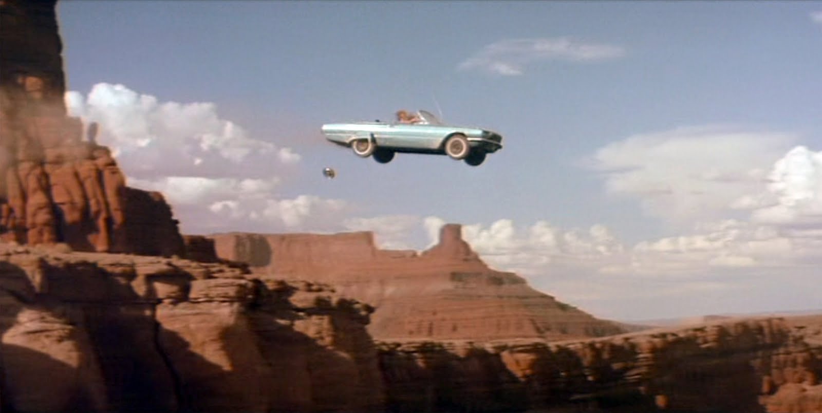
ThelmaLouise4_001Pyxurz

Many are finally beginning to wake up to the fact that the something is very wrong with the weather. Many are finally realizing something profound is happening in our skies. Some are now finally making the decision to get involved with the fight to raise awareness of the lethal climate engineering programs, but are we already too late?

Have the geoengineers already pushed Earth’s natural systems past the point of no return? Based on all available data, the answer is very likely yes. The damage already done to our planet from anthropogenic activity, which includes geoengineering, has guaranteed us a planet that is much less hospitable than the one we have known. However difficult the future looks, we could yet perhaps preserve the planet’s ability to support life if we can stop climate engineering. This battle must be won or all will be lost.

No Natural Weather

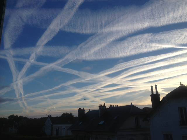
chems

It is imperative that we all work together toward the goal of making the population as a whole understand that virtually all their “weather” is being completely manipulated. That there is NO NATURAL WEATHER at this point. That we are all the victims of “weather warfare” and many of us will soon be climate refugees if we are not able to bring the climate engineering to light and to a halt. On top of all this we are all literally being poisoned by the toxic metal fallout from these programs, but that’s another story.

Geoengineered Drought, Target California

one

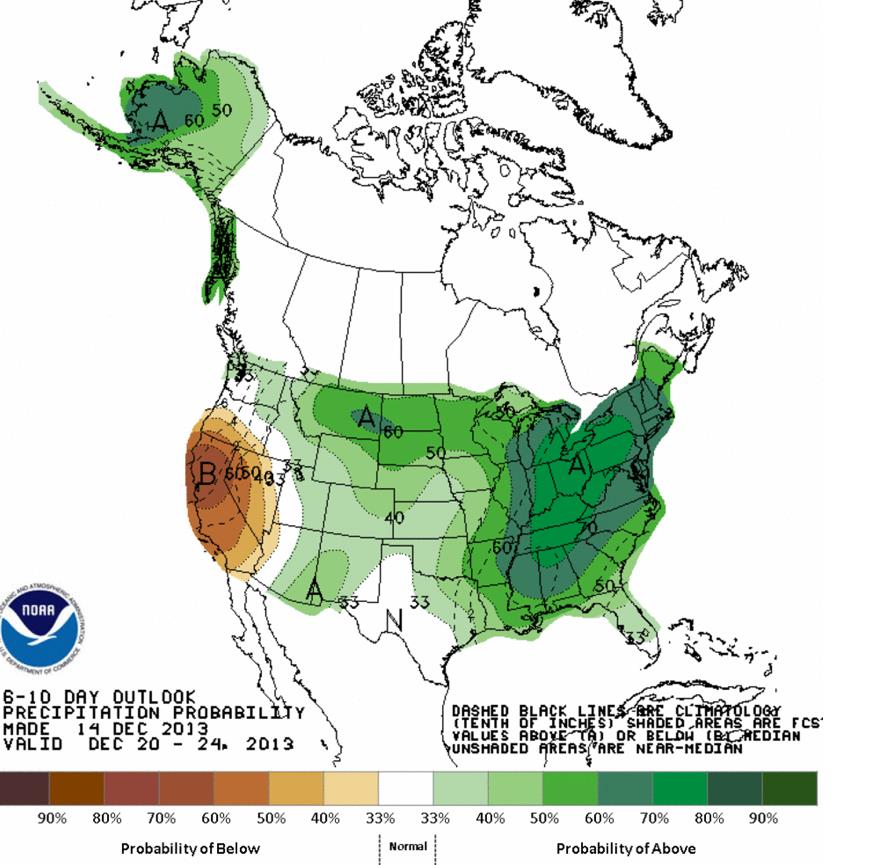
The recent NOAA map above illustrates an unprecedented pattern of precipitation or lack thereof. Almost the entire country is shown at above normal precipitation while California looks like it has a virtual “bullseye” of below normal rainfall predicted (scheduled). One can draw their own conclusions from this map, does this pattern really look natural?

map-1

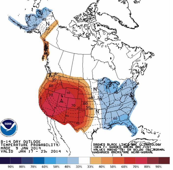
The NOAA map above is about as unnatural as it gets. Welcome to global geoengineering.

map-2

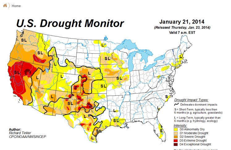
The true severity of the drought in the west is not accurately reflected in the “drought monitor” map above. The actual conditions on the ground are much much worse as California has been descending into ever worsening drought for 7 years now. This season to date there has been no significant rain at all.

haarp

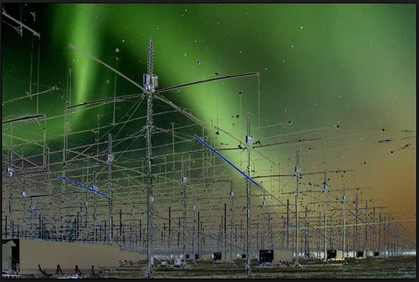
HAARP ionosphere heating facility in Alaska. There are numerous ionosphere heating installations around the globe that are used to manipulate the jet stream into historically unprecedented patterns. The manipulated jet stream is one of several primary factors relating to the climate chaos now being inflicted on planet Earth.

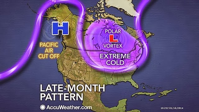
With the combination of constant aerosol spraying and ionosphere heater utilization (HAARP) the climate engineers have effectively cut off the flow of moisture to the state of California. Why? There are likely a number of probable reasons. First, California is possibly a climate “sacrifice zone”. This means that California is collateral damage for the constant parade of engineered snow storms being whipped up further east in the US. The rain blocking high pressure ridge that the climate engineers have locked in place over the western US and the eastern Pacific pushes the jet stream straight north, carrying the moisture with it before rain can come anywhere near California. This moisture then travels as far as Alaska and the Arctic.  The jet is then turned back south as it wraps clockwise around the HAARP/ionosphere heater created dome of high pressure. Then, it is pumped all the way down to the southern US carrying heavily sprayed and chemically ice nucleated moisture with it which enhances the artificial cool down of the eastern US.

polar vortex

Another part of the puzzle is likely this, a population that has no water and can not grow any food does not tend to be in a position to effectively protest the crimes of it’s government. California has historically grown so much food for the nation that the catastrophic drought has very far reaching ramifications. Control the food supply and you control the population. There is also the growing effort by the government to take control of water rights in California and other regions in the west. The climate engineers literally have California by the throat and it does not appear they are going to let go anytime soon. The weather makers can drought California into a desert from top to bottom, we are well on our way to this already. Forests that were green and lush only ten years ago are now wilting, withering, and in many places have already died. In addition to the almost total lack of rain in California caused by the climate manipulation, the jet sprayed aerosols utilized in the geoengineering programs are desiccants. These are materials that adhere to all available moisture in the atmosphere creating very low humidity on the ground under many conditions which further dries out the already parched state. Now lets add the constant record high temperatures that often go along with consistent high pressure. All things considered, its a recipe for creating a dust bowl out of a once beautiful state. Its a method for bringing the population of this state to their knees.

Where Are The Geoengineers Concentrating Their Efforts,
And How Cool Are They Making The Planet Overall?

800xmaps

The NASA temperature analysis map above should make clear where the climate engineers are most focused in their efforts to create a “cool down”. This map illustrates recent temperature trends as compared to the 30 year average. The NASA map clearly shows the only “cooler” places on the planet compared to the long term average. These areas of below normal temperatures are a direct result of massive geoengineering efforts such as those described above. If the temperature variations on this map seem unnatural, they are. Though the US media is trying frantically to convince its population (with considerable success) that the world is in a deep freeze, this is patently false from a global perspective. The radical swings in temperatures and conditions will persist and worsen as the climate engineers literally tear Earth’s natural life support systems apart. The climate engineers can and are radically cooling huge areas, but at the cost of a greatly worsened overall warming and a completely decimated climate system.

What Can We Do?

Everyone can and must help with this all important battle. All must get up off the bench and assist in the critical effort to raise awareness. Get organized with others in your community. Get educated (this means examining real data, not headlines), get credible information to hand out, hold viewings of documentary films like “Look Up” from film maker George Barnes, do whatever it takes to sound the alarm. If we can simply bring the climate engineering crimes to the light of day, and reach critical mass of awareness, the dominos that keep these programs in operation will start to fall.


The year 2013 was the driest in California's recorded history, and predictions for 2014 aren't much better. Three consecutive years of below-normal rainfall have left reservoirs at a fraction of their normal depth, seriously threatening farms in the state that grows half the nation's fruits and vegetables. California Governor Jerry Brown has declared a drought emergency and signed a $687 million drought-relief package into law, and 125 additional firefighters have been hired already in anticipation of a dangerous upcoming fire season. One bright spot: gold prospecting. Amateur prospectors are flocking to the Sierra Nevada foothills, taking advantage of lower water levels to search for gold in riverbeds that have been unreachable for decades.

Houseboats are docked at Bridge Bay in Shasta Lake, which is 100 feet (30 meters) below its normal levels, in Shasta, California, on January 23, 2014. Now in its third straight year of drought conditions, California is experiencing its driest year on record, dating back 119 years, and reservoirs throughout the state have very low water levels. (Reuters/Robert Galbraith)

2

A car sits in dried and cracked earth of what was the bottom of the Almaden Reservoir on January 28, 2014 in San Jose, California.(Justin Sullivan/Getty Images) #

3

Snow cover in the Sierra Nevada mountain range in California in January 2013 (left) and January 2014 (right), compared in this combination of NASA satellite photos. (Reuters/NASA) #

4

A Marine stands his ground as one of the helicopters accompanying U.S. President Barack lands in Firebaugh, California, on February 14, 2014. President Obama pledged to speed federal assistance to help California recover from a crippling drought that is threatening the critical agriculture industry in the No. 1 farm state. (Reuters/Kevin Lamarque) #

5

President Barack Obama speaks to the media on California's drought situation on February 14, 2014 in Los Banos, California.(AP Photo/Los Angeles Times, Wally Skalij) #

6

Shasta Lake, 100 feet below its normal levels, seen behind Shasta Dam with Mount Shasta in the background, on January 23, 2014.(Reuters/Robert Galbraith) #

7

Visitors look over the foundation of a structure from the Gold Rush era town of Mormon Island, now uncovered by receding waters at Folsom Lake -- at 17 percent of its capacity -- in Folsom, California, on January 22, 2014. (Reuters/Robert Galbraith) #

8

A sign posted near an almond farm in Turlock, California, on February 25, 2014. As the California drought continues and farmers struggle to water their crops, the U.S. Bureau of Reclamation officials announced that they will not be providing Central Valley farmers with any water from the federally run system of reservoirs and canals fed by mountain runoff.(Justin Sullivan/Getty Images) #

9

A worker with Better Than Real Artficial Lawns installs an artificial lawn in front of an apartment building in San Jose, California, on January 30, 2014. Artificial lawns have emerged as a water saving alternative for Californians who have been asked to voluntarily reduce water by twenty percent as California is experiencing its driest year on record. (Justin Sullivan/Getty Images) #

10

The sun rises over an oil field on the Monterey Shale formation, where gas and oil extraction using hydraulic fracturing, or fracking, is on the verge of a boom near Lost Hills, California, on March 24, 2014. Critics of fracking in California cite concerns over water usage and possible chemical pollution of limited ground water sources as California farmers are forced to leave unprecedented expanses of fields fallow in one of the worst droughts in California history. (David McNew/Getty Images) #

11

A tractor moves an uprooted almond tree into a shredder at Baker Farming in Firebaugh, California, on February 25, 2014. Almond farmer Barry Baker had 1,000 acres, 20 percent, of his almond trees removed because he doesn't have access to enough water to keep them watered as the California drought continues. (Justin Sullivan/Getty Images) #

12

An empty boat marina at Folsom Lake, at 17 percent of capacity, in Folsom, California, on January 22, 2014.(Reuters/Robert Galbraith) #

13

Visitors take photographs at the bottom of Folsom Lake on January 22, 2014. (Reuters/Robert Galbraith) #

14

The low water level of Morris Reservoir, visible on the backside of Morris Dam on the San Gabriel River in the Angeles National Forest near Azusa, California, on January 22, 2014. (David McNew/Getty Images) #

15

Robert Silva, 72, Mayor of Mendota, California, explains how the state's drought is sure to drive up unemployment in his rural farming town during an interview on January 30, 2014. Five years ago, the last dry year and height of the national recession, farm workers lined up for free food as unemployment exceeding 40 percent in Mendota. Silva fears that this year the food lines will be even longer. (AP Photo/Scott Smith) #

16

A dog hangs around an abandoned farmhouse near Bakersfield, California, on February 6, 2014. California farmers are struggling with diminishing crop water and whether to plant or to tear out permanent crops which use water year-round. About 17 rural communities could soon run out of drinking water and politicians are pushing to undo laws that protect several endangered species. (David McNew/Getty Images) #

17

Rocky shores are exposed by the low waters of San Gabriel Reservoir on the San Gabriel River in the Angeles National Forest on January 22, 2014. (David McNew/Getty Images) #

18

Proprietor Marc Mondavi demonstrates dowsing with "divining rods" to locate water at the Charles Krug winery in St. Helena, California, on February 13, 2014. As water supplies shrink during California's historic drought, vineyard owners and other farmers are looking to an ancient, yet scientifically discredited, source for finding water: dowsers. Also known as water witches, dowsers use so-called "divining rods" made of copper or wood, pendulums or other items to find water deep underground using nothing more than their own intuition. (AP Photo/Eric Risberg) #

19

Morning traffic makes its way toward downtown Los Angeles along the Hollywood Freeway past an electronic sign warning of severe drought on February 14, 2014. (AP Photo/Richard Vogel) #

20

A sign from wetter times warns people not to dive from a bridge over the Kern River, which has been dried up by water diversion projects and little rain, on February 4, 2014 in Bakersfield, California. (David McNew/Getty Images) #

21

Tim Amavisca, 38, and his daughter Hailey, 15, use a sluice box to trap gold flakes on a textured rubber mat as they search for gold along the Bear River near Colfax, California, on March 4, 2014. Amavisca is among the amateur prospectors that have flocked to the Sierra Nevada foothills, taking advantage of the lower water levels to search for gold in riverbeds that have been unreachable for decades. (AP Photo/Rich Pedroncelli) #

22

California rancher Nathan Carver delivers hay to his herd of beef cattle, seen giving chase across the brown-dirt fields of Carver's ranch on the outskirts of Delano, in California's Central Valley, on February 3, 2014. At this time of the year normally, the fields would be covered in lush green grass but the drought has reduced the land to a parched moonscape, and now Carver must spend money to buy hay to feed his herd. Carver remembers tales his grandparents told of the Dust Bowl years in the 1930's, but this is as bad as he has ever seen it in his lifetime, he said. (Frederic J. Brown/AFP/Getty Images) #

23

Chinook salmon smolts are pumped into a tower that separates fish from the water at the Coleman National Fish Hatchery in Anderson, California, on March 25, 2014. Workers trucked approximately 420,000 of the 30.4 million Chinook salmon that will be transported to locations downriver due to the extreme drought. Salmon are typically released from hatcheries into the Sacramento River and its tributaries between April and June to begin their migration into the Pacific Ocean, but this year water levels in the Sacramento River and its offshoots have dwindled to dangerously low levels. (Reuters/Nick Adams) #

24

Thousands of juvenile salmon are dispatched into a holding tank in the Sacramento River in Rio Vista, California, on March 25, 2014. The salmon were trucked more than 200 miles (321 km) from a hatchery on the northern part of the river, as drought conditions in the state have made the river impassable to the young fish. (Reuters/Robert Galbraith) #

25

A houseboat is removed from the disappearing water at Bridge Bay in Shasta Lake, which is 100 feet (30 meters) below its normal levels, on January 23, 2014. (Reuters/Robert Galbraith)

Tuesday, June 16, 2015

Refugees document journey from Nepal to Colorado


Refugees document journey from Nepal to Colorado


Description of . “This is a photograph of my neighbor. She is sieving rice to make food. Though she’s extremely old, she has the power to see the very small pebbles. This is something she does twice a day, both early in the morning and again in the evening. By seeing this photograph, I realize that every person is capable to do work.”<br />-Bhim Bahadur Bhattarai

This is a photograph of my neighbor. She is sieving rice to make food. Though she’s extremely old, she has the power to see the very small pebbles. This is something she does twice a day, both early in the morning and again in the evening. By seeing this photograph, I realize that every person is capable to do work.” -Bhim Bahadur BhattaraiDescription of . “Everything about the photo says Nepal, from the posters on the wall to the men. It reminds me of how much I love Nepal.  I also think about my new American friends from Picture Me Here because they are the reason I can take pictures of my life.”<br />- Keshavi Neupane2 of 19 -“Everything about the photo says Nepal, from the posters on the wall to the men. It reminds me of how much I love Nepal. I also think about my new American friends from Picture Me Here because they are the reason I can take pictures of my life.” - Keshavi NeupaneDescription of . “Mohan is taking water home from the well. The water is for doing laundry. In the camp, Mohan and I did laundry together, 5-6 times a day.  A big family will carry 7-8 times because they have a lot of clothes.”   -Aita Rani Subba3 of 19 -“Mohan is taking water home from the well. The water is for doing laundry. In the camp, Mohan and I did laundry together, 5-6 times a day. A big family will carry 7-8 times because they have a lot of clothes.” -Aita Rani SubbaDescription of . “In the camp, we had to follow a schedule to get water in the morning and evening. This woman is getting water for cooking and drinking. We stand in line to get water. Sometimes we wait one hour. America is very different from Nepal. This country is very fast. Very easy.  When I arrived at the Los Angeles airport I went to restroom. I put my hands under the faucet and the water came. How is it? I felt like someone was giving from above. Chaka ban! Surprised! The air dryer also surprised me. At that time a stranger taught me to dry my hands. I used the hand dryer and it was loud. I was afraid.”    - Mohan Rai4 of 19 -“In the camp, we had to follow a schedule to get water in the morning and evening. This woman is getting water for cooking and drinking. We stand in line to get water. Sometimes we wait one hour. America is very different from Nepal. This country is very fast. Very easy. When I arrived at the Los Angeles airport I went to restroom. I put my hands under the faucet and the water came. How is it? I felt like someone was giving from above. Chaka ban! Surprised! The air dryer also surprised me. At that time a stranger taught me to dry my hands. I used the hand dryer and it was loud. I was afraid.” - Mohan RaiDescription of . “When I see this dirty girl, I took photo. She is standing in front of the poor man house. She looked sad. Maybe she is from the shame caste. The king made the castes in ancient time. Brahmin is the upper caste. Next is Chhetris. Next is Vaishyas (Monger, Tamang, Rai, etc…) and Shudras (Kami, Damai, Sarki, etc…). The lower castes cannot enter into the Brahmin home. The king of the Brahmin made these rules.”   - Mohan Rai<br /><br />“The caste system is often categorized by work people did. Brahmins were smart and were intellectual so they read, write, and performed poojas and such.  Chettris were brave so they were soldiers and fighters (A.K.A. Gurkhas)  Vaishyas were farmers. Finally, the Shudras were locksmiths, laborers, goldsmiths etc. The Damais were musicians. They play music during weddings and other ceremonies and they still do in Nepal and around the globe.”   - Birendra Dhakal5 of 19 -“When I see this dirty girl, I took photo. She is standing in front of the poor man house. She looked sad. Maybe she is from the shame caste. The king made the castes in ancient time. Brahmin is the upper caste. Next is Chhetris. Next is Vaishyas (Monger, Tamang, Rai, etc…) and Shudras (Kami, Damai, Sarki, etc…). The lower castes cannot enter into the Brahmin home. The king of the Brahmin made these rules.” - Mohan Rai “The caste system is often categorized by work people did. Brahmins were smart and were intellectual so they read, write, and performed poojas and such. Chettris were brave so they were soldiers and fighters (A.K.A. Gurkhas) Vaishyas were farmers. Finally, the Shudras were locksmiths, laborers, goldsmiths etc. The Damais were musicians. They play music during weddings and other ceremonies and they still do in Nepal and around the globe.” - Birendra DhakalDescription of . “This woman is my aunt. She is cooking curry with some tomatoes in the bowl beside her. The sunlight scatters from the slats in the wall of her refugee hut.”<br />-Bhim Bahadur Bhattarai6 of 19 -“This woman is my aunt. She is cooking curry with some tomatoes in the bowl beside her. The sunlight scatters from the slats in the wall of her refugee hut.” -Bhim Bahadur BhattaraiDescription of . “These pictures are from Chatara, Nepal. Chatara is one of the holiest places in Nepal for Hindus. There was a big ritual Purana (Storytelling by the priests about the Holy books such as Ramayana, Mahabharata) in Chatara. On the picture with the cow calf, there was a Pooja being performed after which the calf was donated to the priest.”    - Keshavi Neupane7 of 19 -“These pictures are from Chatara, Nepal. Chatara is one of the holiest places in Nepal for Hindus. There was a big ritual Purana (Storytelling by the priests about the Holy books such as Ramayana, Mahabharata) in Chatara. On the picture with the cow calf, there was a Pooja being performed after which the calf was donated to the priest.” - Keshavi NeupaneDescription of . “Diwali is the festival of lights. My relatives and I are lighting candles for the laxmi puja. Because Diwali is a five day festival, the fourth day is the Laxmi Pooja. Laxmi is the goddess of wealth. During the ceremony people pray for wealth and that they never have to suffer from homelessness, joblessness, etc…”    - Keshavi Neupane8 of 19 -“Diwali is the festival of lights. My relatives and I are lighting candles for the laxmi puja. Because Diwali is a five day festival, the fourth day is the Laxmi Pooja. Laxmi is the goddess of wealth. During the ceremony people pray for wealth and that they never have to suffer from homelessness, joblessness, etc…” - Keshavi NeupaneDescription of . “This is a relative who had a stomach cancer. He needed blood transfusions every month. Then one day he did not need blood. We thought he was better but one day he got the disease again and died.  I am Kirati religion. We have a guru. The guru looks at you and tells you your future. We keep the dead people in the house a while. Then we dig and bury them.”    - Mohan Rai9 of 19 -“This is a relative who had a stomach cancer. He needed blood transfusions every month. Then one day he did not need blood. We thought he was better but one day he got the disease again and died. I am Kirati religion. We have a guru. The guru looks at you and tells you your future. We keep the dead people in the house a while. Then we dig and bury them.” - Mohan RaiDescription of . “The woman has to go to the husband’s parents house, when we resettle. I came with my husband to Colorado because that is our culture. My heart was broken to leave my parents. After the camp closes they will go some place far away called Pan Cha Me, in the mountains.  They have a brother they have to take care of in the camp. My step dad does not want to come to America. There was one women who knew my mom and my stepdad. She knew they had lost their partner and told them to marry. They met and fell in love. My step dad likes to hold things in his hands when he takes pictures.“    - Aita Rani Subba10 of 19 -“The woman has to go to the husband’s parents house, when we resettle. I came with my husband to Colorado because that is our culture. My heart was broken to leave my parents. After the camp closes they will go some place far away called Pan Cha Me, in the mountains. They have a brother they have to take care of in the camp. My step dad does not want to come to America. There was one women who knew my mom and my stepdad. She knew they had lost their partner and told them to marry. They met and fell in love. My step dad likes to hold things in his hands when he takes pictures.“ - Aita Rani SubbaDescription of . “This is a picnic with friends. In Nepal we put three stone and make fire and cook food. We play music and dance in the mountains. We cook meat, rice and drink alcohol.  We tell scary and funny stories.”    - Mohan Rai11 of 19 -“This is a picnic with friends. In Nepal we put three stone and make fire and cook food. We play music and dance in the mountains. We cook meat, rice and drink alcohol. We tell scary and funny stories.” - Mohan RaiDescription of . “We came to America to make life. For our kid’s life. There are lots of Nepali people in Grace Apartments and the park is nice.”     - Mohan Rai12 of 19 -“We came to America to make life. For our kid’s life. There are lots of Nepali people in Grace Apartments and the park is nice.” - Mohan RaiDescription of . “This is my Aunt. My father’s sister. They are not refugees since they left Bhutan before the struggle and bought land in Nepal. They are the only ones left in Nepal now. Our whole family resettled in America and they miss us.”  - Chhali Maya Dahal13 of 19 -“This is my Aunt. My father’s sister. They are not refugees since they left Bhutan before the struggle and bought land in Nepal. They are the only ones left in Nepal now. Our whole family resettled in America and they miss us.” - Chhali Maya DahalDescription of . “These women are leaders from the Youth Friends Center (YFC). The YFC is a group in the camp (organized by Caritas, Nepal). They offer vocational training for refugees.”   - Chhali Maya Dahal14 of 19 -“These women are leaders from the Youth Friends Center (YFC). The YFC is a group in the camp (organized by Caritas, Nepal). They offer vocational training for refugees.” - Chhali Maya DahalDescription of . “This wedding picture is from after we arrived in Denver. The woman getting married is my wife’s cousin.”    – Mani Kumar15 of 19 -“This wedding picture is from after we arrived in Denver. The woman getting married is my wife’s cousin.” – Mani KumarDescription of . “We put a ceremonial scarf called a khada over the shoulders of the relatives and friends who are departing as a sign of respect and remembrance.”   - Mani Kumar16 of 19 -“We put a ceremonial scarf called a khada over the shoulders of the relatives and friends who are departing as a sign of respect and remembrance.” - Mani KumarDescription of . “We held goodbye parties for our relatives who were departing.“   - Mani Kumar17 of 19 -“We held goodbye parties for our relatives who were departing.“ - Mani KumarDescription of . “The journey to America was very difficult at times because it was my first time flying for such a long time. We flew from Kathmandu to Hong Kong to LA.”<br />- Mani Kumar18 of 19 -“The journey to America was very difficult at times because it was my first time flying for such a long time. We flew from Kathmandu to Hong Kong to LA.” - Mani KumarDescription of . “I used a camera a lot in the camps to capture the last moments of our relatives before they departed for their destination.”   - Mani Kumar19 of 19 -“I used a camera a lot in the camps to capture the last moments of our relatives before they


Nepal quake survivors hope to rebuild lives one month on

Huddled in a Kathmandu monastery, Nima Lama clutches his prayer beads and thinks of the family he lost when his home was destroyed by a torrent of ice and rock one month ago.

His wife and parents were among the hundreds killed when the picturesque Langtang valley -- home to a trekking village with the same name -- was hit by a huge avalanche triggered when a massive 7.8-magnitude earthquake struck Nepal on April 25.

"It felt like a bomb had exploded, I hid behind a boulder as rocks fell everywhere," the 35-year-old trekking guide told AFP in the monastery, as monks chanted prayers for the dead.

Nima Lama (R) cries during a Buddhist ceremony at the Yellow Gumba in Kathmandu

+4

Nima Lama (R) cries during a Buddhist ceremony at the Yellow Gumba in Kathmandu ©Ishara S.Kodikara (AFP)

More than 8,600 people have lost their lives since the earthquake hit Nepal last month, followed by another on May 12, destroying nearly half a million houses and leaving thousands without food or water.

The government estimates the disaster has already cost the impoverished country around $10 billion -- half its annual GDP -- and with the vital tourist industry now crippled, experts fear it will struggle to rebuild.


The avalanche destroyed access to the popular Langtang trekking route that once helped hundreds of villagers earn their livelihood and enabled Lama to build two thriving teahouses, both now destroyed.

It turned a valley renowned for its beauty into a desolate graveyard, showering the village with rocks and ice and stripping bark from surrounding trees.

Frantic with worry, Lama joined soldiers and other villagers as they dug through the debris to find survivors and recover the bodies of loved ones.

"It was like someone swept it up with a large broom. As I walked back I couldn't tell where I was, everything was buried," said Lama, who only survived as he was in a nearby hamlet on the day of the earthquake.

Security forces evacuated more than 500 survivors, including tourists, from surrounding villages while smaller landslides continued to rain down the slopes, ringed with snow-capped peaks.

- 'We cannot rebuild alone' -

A month on, the risk of landslides from the ongoing aftershocks still wracking Nepal has forced thousands of survivors to leave their homes and camp out in open fields.

Although Lama, who is now living in a makeshift refugee centre in the capital, and his fellow villagers are keen to return home, district officials say Langtang is not safe for human habitation until the avalanches and rockslides end.

UN humanitarian coordinator in the country Jamie McGoldrick warned that with just weeks left before the arrival of the monsoons, the window to help quake victims is closing fast.

"Before it gets worse we have to get enough food supplies and shelter materials in high remote areas and also enough logistics to enable us to deliver (aid) in difficult to reach areas," he told AFP in an interview.

More than 20 countries have been involved in the rescue operations, but aid agencies are still struggling to cope and the UN says it has received only around a fifth of the $415 million it needs.

Experts fear the situation could be compounded by a surge in food prices after the widespread destruction of farmland and irrigation networks, as well as loss of livestock.

The Asian Development Bank predicts food price inflation could reach double-digit levels, particularly as many farmers will be unable to plant crops for the next harvest before the rains arrive.

"With the onset of the monsoon, further supply disruptions are likely due to landslides," the bank warned in a blog.

Chandan Sapkota, economist at the ADB's Nepal office, predicted GDP growth could slow to 3.8 percent this year, from 5.2 percent in 2014, due to a slowdown in agriculture, services such as tourism and other industries.

McGoldrick said Nepal, which has an annual budget of only $6.4 billion and has appealed for $2 billion to help rebuild its crippled infrastructure, will need support long after the initial search and rescue operations are over.

"There should be an even-handed response to search and rescue, the relief phase and also the reconstruction phase... if you want to rebuild people's lives," he said.

For survivors like Lama, who is determined to return home and rebuild a life shattered by tragedy, such support will be crucial.

"We all have a single voice, we want to go back to our own village", he said. "But we have nothing left (and)...we cannot rebuild alone."

Graphic on the Nepal quake, one month after it struck leaving more than 8,600 people killed

+4

Graphic on the Nepal quake, one month after it struck leaving more than 8,600 people killed ©- (AFP Graphic)

A Nepalese child and young Buddhist monk are seen at a camp for earthquake survivors in Kathmandu

+4

A Nepalese child and young Buddhist monk are seen at a camp for earthquake survivors in Kathmandu ©Ishara S.Kodikara (AFP)

Young Nepalese Buddhist monks carry relief materials at a camp for earthquake survivors in Kathmandu

+4

Young Nepalese Buddhist monks carry relief materials at a camp for earthquake survivors in Kathmandu ©Ishara S.Kodikara (AFP)


Mount Everest shifts 1.2 inches south-west after shock of Nepal earthquake

  • The 7.8-magnitude quake devastated the country on April 25, killing 8,700
  • Reversed the gradual north easterly course of the world's tallest mountain
  • Mount Everest moved 1.2 inches (three centimetres) to the southwest
  • Expert compared the movement to that of a rubber ball when it's poked


The world's tallest peak, Mount Everest, has shifted 1.2 inches (three centimetres) south-west as a direct result of the Nepal Earthquake.

The 7.8-magnitude quake devastated the country in April, killing more than 8,700 people and destroying important monuments.

The disaster has also reversed the gradual north-easterly course of the mountain, according to China’s National Administration of Surveying, Mapping and Geoinformation.

The world's tallest peak, Mount Everest (seen here from basecamp) moved 1.2 inches (three centimetres) to the southwest because of the Nepal earthquake

+5

The world's tallest peak, Mount Everest (seen here from basecamp) moved 1.2 inches (three centimetres) to the southwest because of the Nepal earthquake

Over the past decade, Everest has moved 16 inches (40cm) to the north-east at a speed of 1.6 inches (4cm) per year, Chinese state media reported.

The mountain also rose 1.2 inches (3cm) over the same time period.

Professor James Jackson, a geologist at Cambridge University, told MailOnline that rocks are bendy and during the earthquake process, the Earth behaves a little like a rubber ball. 

The 7.8-magnitude quake devastated the country in April, killing more than 8,700 people in the country and destroying important monuments. On April 25, an avalanche struck base camp (shown on the map)

+5

The 7.8-magnitude quake devastated the country in April, killing more than 8,700 people in the country and destroying important monuments. On April 25, an avalanche struck base camp (shown on the map)

MIGHTY MOUNT EVEREST

Mount Everest’s peak is 29,029 feet (8,848 metres) above sea level, which is around the cruising altitude of a jet airliner.

The world's highest peak is located in the Mahalangur section of the Himalayas.

Data suggests the world’s highest mountain gets higher by three to five millimetres a year, so that every time a team reaches the summit they are setting a new altitude record.

Mount Everest attracts highly experienced mountaineers who tackle one of its two climbing routes - one approaching the summit from the southeast in Nepal, and the other from the north in Tibet.

The routes aren't technically particularly difficult, but pose dangers including altitude sickness, weather and wind as well as avalanches.

By March 2012, Everest had been climbed 5,656 times with 223 deaths.

Although shorter mountains can be longer or steeper climbs, it's so high the jet stream can hit it so climbers face winds exceeding 200 mph when the weather shifts.

The mountain's height was first decided in 1856, when Andrew Waugh announced Everest (then known as Peak XV) as 29,002 feet (8,840 metres) high, after several years of calculations based on observations made by the Great Trigonometric Survey.

Now the height is set and recognised by Nepal and China.

He compared the epicentre of the earthquake, which struck on April 25, to a ball being poked with a finger, while the rest of the ball spreads outwards a little.

The epicentre of the earthquake was near Kathmandu with Everest around 100 miles (161 km) to the east. 

While the earthquake itself was less forceful on the mountain, it still triggered deadly avalanches killing 18 people and leaving its climbing base camp in ruins, causing the authorities in both China and Nepal to cancel all climbs for this year.

The mountain straddles the border between the two countries.

Professor Jackson said that before the earthquake, India was gradually moving into Nepal, so that the country was effectively being compressed and the mountain slightly squeezed.

When the earthquake struck, Kathmandu rebounded by around seven feet (two metres) and the mountain rather less, to readdress the balance.

‘This happens all the time,’ he said, citing the Japan earthquake in 2011 as an example.

‘Japan compressed like a ball – east and west – but after the earthquake this reversed and the country extended 10 feet (three metres).'

Geologists call the effect elastic rebound because energy is stored up before an earthquake and release afterwards.

Two earthquakes shook the region – one on April 25 and another May 12 – which in combination triggered landslides and destroyed half a million homes, leaving thousands without shelter just weeks ahead of monsoon rains. 

While the second quake was still strong, with a magnitude of 7.3, it didn’t move the mountain, according to reports. 

Terrifying moment avalanche hits Everest base camp

The epicentre of the earthquake was at Kathmandu with Everest around 100 miles to the east. While the earthquake itself was less forceful on the mountain, it still triggered deadly avalanches. Here, a cloud of snow and debris triggered by an earthquake roars towards Everest base camp

+5

The epicentre of the earthquake was at Kathmandu with Everest around 100 miles to the east. While the earthquake itself was less forceful on the mountain, it still triggered deadly avalanches. Here, a cloud of snow and debris triggered by an earthquake roars towards Everest base camp

The quake promoted the authorities in both China and Nepal to cancel all climbs for this year. Here, an injured person is loaded onto a rescue helicopter at Everest base camp on April 26, a day after an avalanche devastated the camp

+5

The quake promoted the authorities in both China and Nepal to cancel all climbs for this year. Here, an injured person is loaded onto a rescue helicopter at Everest base camp on April 26, a day after an avalanche devastated the camp

Days after the disaster, Professor Jackson estimated the vertical and horizontal motion caused by the quake would be less than four inches (10cm), National Geographic reported. 

He said that the 1.2 inch movement south west is what he would expect from a quake of this magnitude.

On April 29, scientists said preliminary data collected by the European Sentinel-1A radar satellite suggested that Everest had shrunk in height by an inch (2.5cm), while ground closer to Kathmandu may have risen by as much as three feet (one metre).

Shocking video shows massive landslide on Nepal/Tibet border

On April 29, scientists said preliminary data collected by the European Sentinel-1A radar satellite suggested that Everest had shrunk in height by an inch (2.5cm). The peak of the mountain, which is 29,022 feeet tall is pictured from a plane (stock image)

+5

On April 29, scientists said preliminary data collected by the European Sentinel-1A radar satellite suggested that Everest had shrunk in height by an inch (2.5cm). The peak of the mountain, which is 29,022 feeet tall is pictured from a plane (stock image)


What is next for China when Scorched Earth in 2100


Beijing says it has nearly completed its controversial land reclamation project in the South China Sea

  • The real war begins when climate change increase temperature and rise of sea levels making coastal territories uninhabitable
  • China has announced it has almost completed work on the Spratly Islands
  • Bejing has been involved with the project for almost the past 20 years
  • A U.S. Naval aircraft was recently intercepted over the Spratly Islands
  • The American pilot refused to comply with the Chinese demand 

China has announced it has almost completed reclaiming land on the Spratly Islands which are the centre of a major international dispute in the South China Sea.

Beijing wants to establish a maritime outpost on the islands, despite the objections of several neighbouring countries.

China has claimed most of the South China Sea and recently tried of force a US Navy P-8 surveillance plane from the area. The US aircraft refused to comply with the Chinese demand claiming they were flying in international airspace.

+8

China has been busy reclaiming land  in the South China sea in an effort to advance territorial claims

+8

China began working the massive land reclamation project back in 1998 causing tensions with its neighbours

+8

Several neighbouring countries have all announced claims on part of the Spratly Islands, pictured

According to Chinese Foreign Ministry spokesman Lu Kang, the reclamation projected should be completed in the near future.

He said: 'Based on our understanding from the relevant authorities, in accordance with the set work plan, the land reclamation project for China's construction on some islands and reefs on the Nansha islands will be completed soon.' The statement used the Chinese name for the Spratlys.

China claims most of the South China Sea, through which $5 trillion in ship-borne trade passes every year. The Philippines, Vietnam, Malaysia, Taiwan and Brunei also have overlapping claims.

Philippines defence ministry spokesman Peter Paul Galvez urged China to refrain from what he called selfish acts.

He said: 'We reiterate that their activities if not stopped only draws the world closer to further uncertainties and untoward incidents with irreparable consequences.'

+8

The Chinese have been busy building military structures on various islands and reefs across the sea

Disputed islands in South China Sea seen from US spy plane

+8

China has announced that some of its new structures on the Spratly Islands will be fully operational shortly

U.S. officials have said the pace and scale of China's reclamation work far outstripped that of other claimants. One official has said that before January 2014, China had only reclaimed about five hectares, but this had soared to 2,000 acres (800 hectares), expanding the acreage on outposts it occupies by over four hundred times.

Recent satellite images show a hive of building and other work on the new islands.

Military facilities for example are under construction on Fiery Cross Reef, including a 3,000-metre (10,000-foot) runway and airborne early warning radars, which could be operational by the year-end, according to one U.S. commander.

The Foreign Ministry reiterated China's stance that the islands would help with maritime search and rescue, disaster relief, environmental protection and offer navigational assistance as well as have undefined military purposes.

+8

It is understood that China wants to use the new forts to justify its territorial claim over large areas of the sea

+8

Approximately $5billion worth of trade uses the shipping lanes in the vicinity of the Spatly Islands,

The construction was within the scope of China's sovereignty, the Foreign Ministry said, adding it would not affect freedom of navigation and overflight in the South China Sea.

The Chinese statement did not say when precisely the work would end but described the work as 'lawful, reasonable, sensible'.

China, which regards almost all the South China Sea as its own, has intensified its building of artificial islands and facilities including airstrips in the contested waters in recent months.

The South China Sea - which is believed to be home to important oil and gas reserves - is a major shipping route for international trade.

The Chinese military last month ordered a US Navy P-8 Poseidon surveillance plane to leave an area above the Spratlys.

But the American aircraft ignored the demand and said it was flying in international airspace.

US Defense Secretary Ashton Carter said last month that while other countries had also established outposts, China had reclaimed over 2,000 acres (809 hectares) in the past 18 months - more than all other claimants combined.

THE SOUTH CHINA SEA DISPUTE OVER ARCHIPELAGO DISCOVERED BY BRITISH SAILOR CAPTAIN RICHARD SPRATLY

+8

The dispute centres around hundreds of tiny shoals, reefs and islets in the South China Sea known as the Spratlys and the Paracels.

Several south Asian countries stake claim to the territory, though China tries to control the largest portion of the archipelago.

Beijing has claimed its right to the collection of land masses is 2,000 years old which, they say, includes the islands in Chinese history.

Taiwan supports its claim, and has its own airfield on the island of Taiping.

Vietnamese officials say their government has ruled over the land since the 17th century whilst the Philippines, the closest geographically, says the islands belong to them.

In 1974, Chinese forces seized the Paracels from Vietnam, killing 70 troops.

There were further clashes between the two countries in 1988, with 60 Vietnamese soldiers killed.

In 2012 China and the Philippines were embroiled in a lengthy maritime standoff over a Scarborough Shoal.

The Filipino military employed its largest warship for the dispute over the stretch of water which they call Panatag.

Upon boarding a Chinese military vessel for inspection, officials claimed they found live sharks, clams and illegal reef.

Later, Vietnamese border agencies refused to stamp passports asserting Chinese sovereignty over a handful of the islands and in January it was claimed China would be taken to a UN tribunal to challenge its stake.


Scorched Earth in 2100:


Nasa maps reveal how climate change will cause temperatures to soar

  • Nasa has released 11 terabytes of data predicting temperature and rainfall
  • It allows scientists to predict climate change for individual towns and cities
  • A map released by Nasa shows large areas in July 2100 will exceed 45°C

It looks like the world could be a much hotter place by the end of the century.

New data released by Nasa scientists is revealing how temperature and rainfall patterns around the world may change by the year 2100.

Using climate change predictions based on increasing levels of carbon dioxide, the data reveals what may happen to the climate in individual towns and cities.

Scroll down for an interactive map

Nasa has released new data that show how temperature and rainfall patterns will change around the world by 2100: This annotated map, produced using the data, shows the maximum daily temperatures in July under climate scenarios that predict carbon dioxide levels in the atmosphere will reach 935 parts per million

+5

Nasa has released new data that show how temperature and rainfall patterns will change around the world by 2100: This annotated map, produced using the data, shows the maximum daily temperatures in July under climate scenarios that predict carbon dioxide levels in the atmosphere will reach 935 parts per million

Much of the data is still in raw form for now to allow scientists to run models on a daily timescale.

However, a map of the world released by Nasa, which shows the predicted temperature for July 2100, provides some clues for what the world may look like.

By that time, carbon dioxide levels in the atmosphere will have reached 935 parts per million, meaning the gas comprises nearly 0.1 per cent of the atmosphere.

Earlier this year carbon dioxide levels reached 400 parts per million.

If by the end of the century carbon dioxide in the atmosphere more than doubles, much of Africa, South America and India will endure average daily maximum temperatures of more than 45°C.

Jerusalem, New York, Los Angeles and Mumbai could see summer temperatures reaching these levels too.

London will experience temperatures in the mid 20s and Paris could see its July temperatures reaching the low 30s.

To use the interactive map, type your city into the search field, and then use the slider to how temperatures will change over time

Ellen Stofan, chief scientist at Nasa, said: 'Nasa is in the business of taking what we've learned about our planet from space and creating new products that help us all safeguard our future.

'With this new global dataset, people around the world have a valuable new tool to use in planning how to cope with a warming planet.'

The new dataset is the latest product from Nasa's Earth Exchange (NEX), a big-data research platform within the NASA Advanced Supercomputing Centre its Ames Research Center in California.

The data shows projected changes worldwide in response to rising carbon dioxide levels and can be viewed on a daily timescale for individual towns and cities.

Unlike other climate prediction maps, which tend to show how global temperatures will differ from a pre-industrial average or current levels, the data gives predicted values.

Nasa says the data will help scientists and planners better understand the risks facing the world due to climate change.

EVEREST'S GLACIERS TO VANISH

Glaciers in the Everest region of the Himalayas could be almost completely eradicated by 2100 due to greenhouse gas emissions, scientists have warned.

Models show that a decrease of 99 per cent by the end of the century is likely if emissions continue to rise, and even 70 per cent is possible if emissions are reduced.

The study paints a grim picture of the impact of climate change on the world's highest peak.

The research was carried out by scientists from Nepal, the Netherlands and France.

They studied weather patterns in the atmosphere and then created a model of conditions on Everest to determine the future impact of rising temperatures on its glaciers.

Increased temperatures will not only increase the rates of snow and ice melt, but can also result in a change of precipitation from snow to rain at critical elevations, where glaciers are concentrated.

Together, these act to reduce glacier growth and increase melting in the area.

Hundreds of millions of people rely upon the fresh water that is provided every summer from rivers that are fed by the Himalayan glaciers.

It may also allow them to better plan for climate related hazards such as drought, floods, heatwaves and losses in agricultural productivity.

An earlier set of data released by Nasa in 2013 providing climate projections for the United States is already being used to calculate risks to the nation's agriculture, forests, rivers and cities.

Dr Ramakrishna Nemani, Nasa's Earth Exchange project scientist, said: 'This is a fundamental dataset for climate research and assessment with a wide range of applications.

'Nasa continues to produce valuable community-based data products on the Nex platform to promote scientific collaboration, knowledge sharing, and research and development.'

Nasa's new data, which totals more than 11 terabytes, integrates actual measurements from around the world with data from climate simulations.

Nasa has released new data that show how temperature and rainfall patterns will change around the world by 2100.

+5

Nasa has released new data that show how temperature and rainfall patterns will change around the world by 2100.

Maximum temperatures in North Africa, the Middle East and northern India will exceed 45°C by 2100, as can be seen in the close up of the region from the maps produced using Nasa's new climate projection data set

+5

Maximum temperatures in North Africa, the Middle East and northern India will exceed 45°C by 2100, as can be seen in the close up of the region from the maps produced using Nasa's new climate projection data set

How the Earth's land surface temperature has changed


It provides both rainfall and temperature projections at a resolution of around 15.5 miles (25km), between 1950 and 2100 across the entire globe.

The map shows that much of North Africa, India and equatorial parts of South America will face summer temperatures in July that regularly exceed 45°C.

Exactly how much this differs from current temperatures is not clear as Nasa has not released maps showing comparative temperatures.

However, daily average high temperatures in Africa, for example, can reach 47°C in July although the daily mean temperature is around 39°C.

For those with the computing power and hard drive space, the data can be downloaded here.

This close up of northern South America and central America shows how the region will be effected by 2100

+5

This close up of northern South America and central America shows how the region will be effected by 2100

By comparison this map shows the average land surface temperatures around the world in July 2014. Much of north Africa, the Middle East and the west coast of the United States experienced temperatures of 45°C

+5

By comparison this map shows the average land surface temperatures around the world in July 2014. Much of north Africa, the Middle East and the west coast of the United States experienced temperatures of 45°C